|
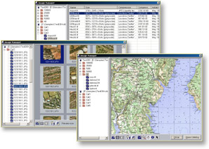
features & benefits Image Management Inside ImageSTOR database images are organized in catalogs, groups of spatially connected images. ImageSTOR uses geo-spatial information to automatically arrange images into a new virtual image covering a larger area. These image catalogs are then used as single 'units' for display in ImageSTOR or external applications like ArcView (no more hassle with dozens of TIFF images and their respective .TFW files). Your image database is browsed and managed with Image Manager, a simple user interface with hierarchical view of your image catalogs in the left-hand pane, and previews of your assets in various forms in the right-hand pane. Image Manager can be accessed directly from ArcView, enabling fast and simple locating of required images.
Additional features simplify image management and enable maximum utilization of your image assets: once images are stored, they are easily copied and moved between catalogs, regrouped in different ways, replaced with new images or deleted from the database. Image metadata can be entered and searched, and creation of sub-catalogs (hierarchical structure) enables efficient organization of very large image sets. Image Compression
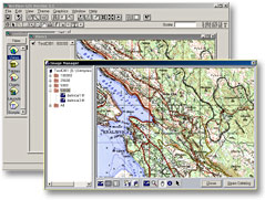
GIS Integration ImageSTOR can be integrated with your GIS system through extension that enables access to ImageSTOR databases from within your favorite GIS software. Using ImageSTOR's Image Manager you can quickly locate required image catalog and add it to the current project. Imagery is then interactively extracted in real-time based on user's area of interest and required resolution. Process is totally transparent and fully integrated into the existing workflow. ImageSTOR catalogs are used like ordinary TIFF files, only much, much faster?Currently ImageSTOR provides extension for ESRI's ArcView (version 3.1 or later). Support for other GIS software will be available soon.
ImageSTOR Professional ImageSTOR Professional is the main part of the ImageSTOR system. It is used for database creation and maintenance, but it also provides all the features required for efficient exploration and display of stored image assets. It can create and access databases in local file system or use ImageSTOR Server for image storage. Additionally, ODBC support is provided for integration with existing RDBM systems. ImageSTOR Professional also contains extensions that enable access and management of ImageSTOR databases from within other GIS / CAD software packages. ImageSTOR Professional has no limit on number of images or amount of data that can be processed in single compression session. ImageSTOR Server ImageSTOR system is most efficient when used in local networks, with many users sharing the same image database. ImageSTOR Server provides true client-server architecture, enabling image access over TCP/IP networks without file sharing. Data access speed is improved through optimized network communication, multithreaded architecture and intelligent image caching. Multiple users can read and modify the database (add images) simultaneously: you can significantly speed up the compression process by using your workstations in parallel. ImageSTOR Server is free but ImageSTOR Professional is required for database creation and maintenance. ImageSTOR Viewer ImageSTOR Viewer is used for easy and efficient exploration of stored image catalogs. It does not include any of the database modification features. ImageSTOR Viewer can be freely copied and distributed to all users who need access to ImageSTOR databases. ImageSTOR Viewer also contains all the available extensions for other GIS software packages. Additional Features
|
|||||||||||||||||||||||||||||||||
 Real-time compression preview is provided for easy evaluation of the image compression methods and options. You can experiment and see the effects of compression on a small sample of your image before adding hundreds of images to the database. Compression methods include true lossless, JPEG and wavelet (JPEG2000 compression technology will be integrated as soon as it is available). All methods can be combined with region-based color reduction (different parts of the image are using different color palettes). Lossless compression with color reduction is particularly effective for storing scanned topographical maps.
Compression is based on a quality parameter (not image compression ratio), which results in uniform image quality across all stored assets. Compression parameters used in each catalog are also preserved between compression sessions.
Real-time compression preview is provided for easy evaluation of the image compression methods and options. You can experiment and see the effects of compression on a small sample of your image before adding hundreds of images to the database. Compression methods include true lossless, JPEG and wavelet (JPEG2000 compression technology will be integrated as soon as it is available). All methods can be combined with region-based color reduction (different parts of the image are using different color palettes). Lossless compression with color reduction is particularly effective for storing scanned topographical maps.
Compression is based on a quality parameter (not image compression ratio), which results in uniform image quality across all stored assets. Compression parameters used in each catalog are also preserved between compression sessions.
|
|
|||
|
|
|||
|
|
|||
| • ImageSTOR | |||
| - features & benefits | |||
| - developer support | |||
|
|
|||
|
|
|||